
Capital updates · Dated buyer research
Amaravati’s flood question: what the maps show, and what safety requires
What satellite imagery, elevation data, flood records and international cities reveal about Amaravati’s flood hazards, operating protection and the evidence still needed.
Property Desk research context
Amaravati has flood hazards that require serious engineering. That does not make the entire location unsuitable for a city. Equally, the existence of a mitigation programme does not establish that every neighbourhood is safe today.
The evidence supports a conditional case for development: build and verify the protection as the city grows. Singapore, Rotterdam and the Tokyo metropolitan region show that cities can manage difficult water conditions. They also show what credible reassurance looks like: mapped protection boundaries, connected drainage, tested infrastructure, maintenance and plans for events beyond the design limit.
The political argument becomes clearer when we separate three questions: what flooded in a particular event, what can flood under other conditions, and what protection is actually operating.
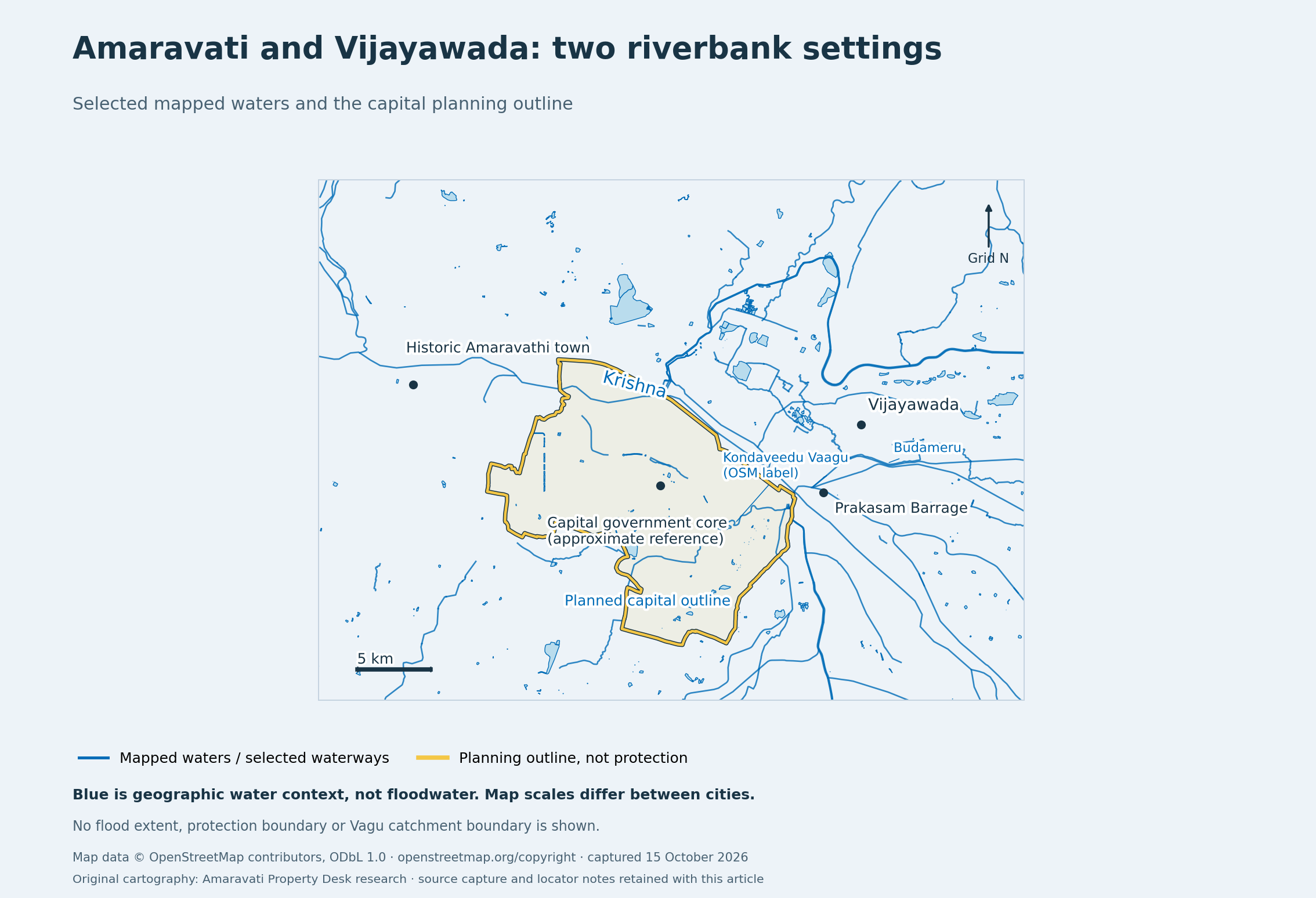
Start with the Krishna and two different drainage systems
In September 2024, parts of Vijayawada suffered severe flooding associated with Budameru breaches. Across the Krishna, the World Bank’s later assessment recorded that the Amaravati program area survived the recent flood. These records undermine a categorical claim that Vijayawada is safe while Amaravati is uniquely unsafe. They do not establish a comparable future flood probability for either city. MHA situation report, PDF page 8 [2]; World Bank technical assessment, paragraph 132, PDF page 57 [3].
The satellite record also needs its full context. NRSC’s RISAT-1A product acquired at 06:00 IST on 3 September 2024 shows different patterns on the two banks. Its southern panel includes water-covered tracts near the southern capital area. That is inconsistent with treating the entire capital as uniformly submerged, and it cannot certify that every part of Amaravati remained dry. This preliminary product does not distinguish every flooded field from seasonal standing water or establish damage to buildings. Original NRSC product, PDF pages 3–4 [4].
Amaravati’s Kondaveeti Vagu and Pala Vagu drainage has its own constraints. Rainfall within the city and its upstream catchment must reach an outlet. A high Krishna level can restrict discharge. An embankment can exclude river water while leaving rainwater inside needing storage and a working outlet. Being on the opposite bank is relevant geography; it does not remove this interaction. World Bank assessment, paragraphs 101–111 [3].
Is Vijayawada’s left bank technically safer?
A bank-wide left-bank safety advantage is not established by the evidence reviewed. Left and right are defined looking downstream. Around this reach, Vijayawada is on the left/north-eastern side and the planned Amaravati city is on the right/south-western side. Those labels do not describe ground height or flood protection. Compare sites in the same hydraulic reach, and specify whether they are upstream or downstream of Prakasam Barrage. USACE HEC-RAS cross-section convention [5].
There is technical evidence of hazard on the Vijayawada side. NRSC published a Budameru event simulation using a 2.5-metre CartoDEM, modelled flood depths and a satellite flood-extent comparison. It concerns the 2024 Budameru event and its study area; it is not a future safety ranking of the two banks. The state’s irrigation account also documents a Krishna left-margin flood-protection-wall project at Ramalingeswara Nagar. That historical/undated account’s completion percentage must not be treated as current commissioning evidence. NRSC Budameru model, PDF pages 4–8 [6]; Krishna district irrigation account [7].
On the Amaravati side, the documented constraints are Kondaveeti/Pala runoff, flat low tracts and restricted outflow when the Krishna is high. A higher site on either bank may have lower river-inundation exposure, but its surveyed ground/floor levels must be tested against the relevant scenario water level. A city-average height cannot substitute for that comparison. World Bank assessment, paragraphs 101–112 [3].
A defensible ranking requires the same flood scenarios, compatible elevation references and current protection assumptions on both sides, including tributary/local rain, embankment failure and pump/power failure. The records reviewed do not provide that matched comparison. Vijayawada’s 2024 losses rule out blanket immunity; they do not prove a general right-bank advantage or equal risk between the banks.
The historical evidence also resists a simple slogan:
| Record | What it supports | What it does not establish |
|---|---|---|
| 2009 Krishna flood, described retrospectively in APCRDA’s 2018 EIA | The report says the capital site escaped that event because of the bund and sluices. | Immunity to other river levels, local storms or infrastructure failures. |
| 2018 environmental baseline | The EIA describes annual inundation of some land by Kondaveeti Vagu. | An observed annual census showing the whole future city submerged every monsoon through 2026. |
| September 2024 event | Severe flooding around parts of Vijayawada; reported survival of the capital program area; satellite evidence of local southern-area water coverage. | A city-wide safety certificate or a matched comparison of future risk. |
The first two statements come from different sections of the same official study: river protection and local drainage are different mechanisms. 2018 EIA, sections 1.5.1 and 3.1.1, PDF pages 20 and 38 [8].
What elevation can—and cannot—tell us
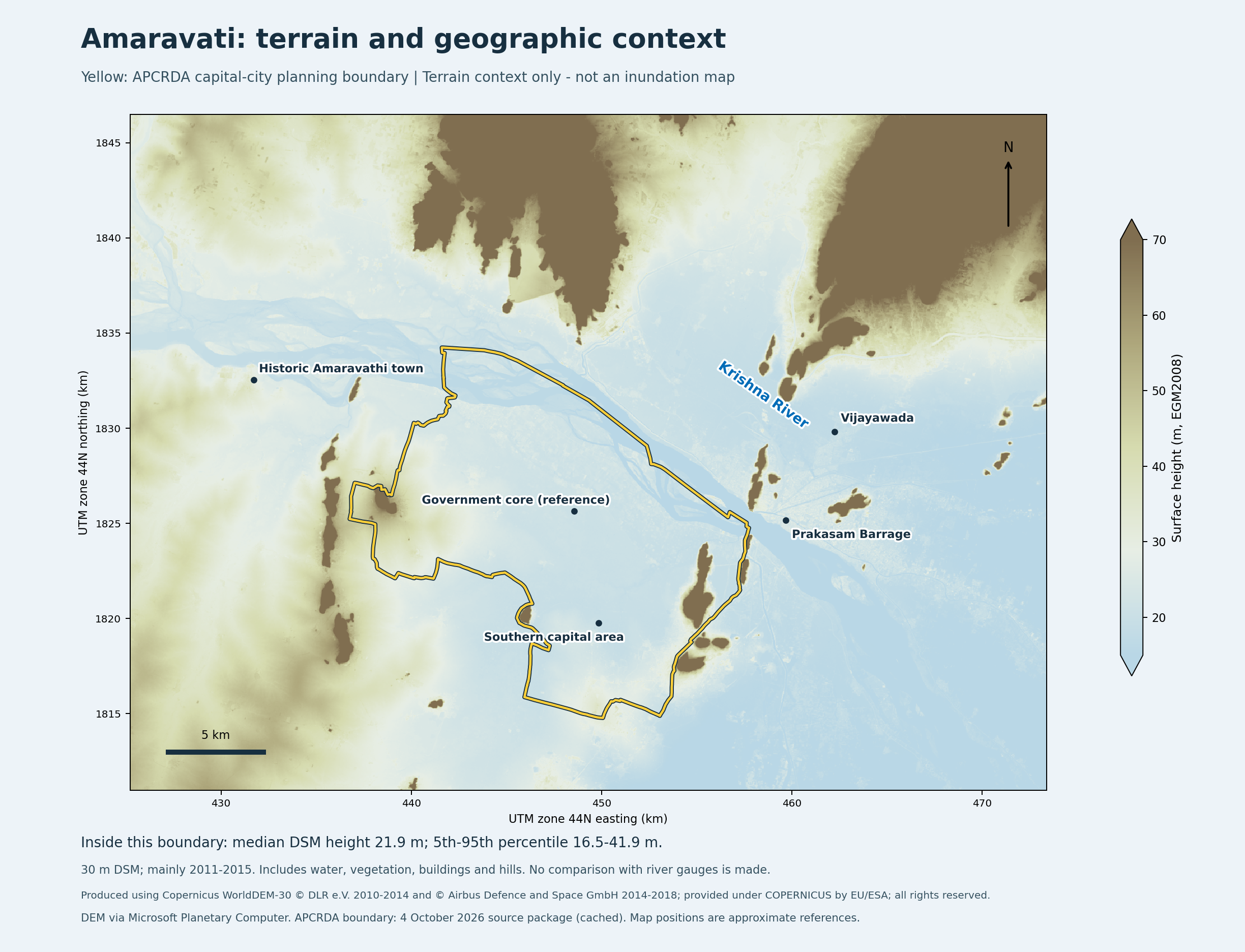
Our 30-metre Copernicus surface-model calculation across the approximately 217.6 km² planning boundary gives a median sampled height of 21.9 metres, with the 5th and 95th percentiles at 16.5 and 41.9 metres. These describe the distribution of modelled surface heights; they are not minimum and maximum ground elevations. The calculation includes river, vegetation, buildings and hill areas within the boundary. The underlying TanDEM-X observations principally date from 2011–2015. Calculation receipt [9]; Copernicus product description [10].
Elevation is useful for finding low tracts and understanding drainage gradients. It cannot answer the safety question on its own. Water levels, embankments, local depressions, blocked drains, outlet conditions and building levels matter. Nor should a Krishna gauge reading or a local engineering reduced level be subtracted directly from this satellite model without reconciling the vertical references.
The 2025 hydrogeomorphological study itself describes seasonal inundation, flat gradients and restricted outflow when the Krishna is high. It also describes further hydrological modelling, urbanisation assumptions and a climate-uplift scenario. Those are evidence of study and design development; we have not independently validated the model or final construction. APCRDA-commissioned study, PDF pages 25 and 42–45 [11].
Separate operating protection from promises
The government’s acknowledgment of drainage problems is a reason to examine the response. The status of each component matters more than the total announced expenditure.
| Component | Evidence found | Status this article can support |
|---|---|---|
| Existing Kondaveeti/Undavalli pumping station | The World Bank documents 150 m³/s commissioned; APCRDA’s 2025 compliance account reports operation during the 2024 storm. | Commissioning documented and past operation reported. Current availability and reliability logs were not inspected. |
| Vagu improvements, detention reservoirs and gravity canal | APCRDA’s compliance account says flood works commenced in June 2025. | Works reported started. Completion and commissioning of the connected network were not verified. |
| Second Undavalli station, 8,400 cusecs | G.O.Rt.No.2 of 1 January 2026 authorises contract award with 15-year operation and maintenance. | Award authorised. The additional capacity cannot yet be counted as operating protection on the evidence reviewed. |
| Finance concurrence for the second station | G.O.Rt.No.184 of 16 February 2026 concurs with the earlier administrative sanction. | A finance decision. It is not a commissioning or performance record. |
Sources: World Bank assessment [3]; APCRDA compliance report, PDF page 6 [12]; January order [13]; February order [14].
There is a second distinction worth public attention. The compliance package describes major canals, detention and pumping designed for a 100-year, 24-hour rainfall event. Its embedded Climate Change Action Plan describes five-year rainfall design for LPS storm drains. A headline about “100-year protection” must not erase the different standard at neighbourhood level. Compliance report, PDF page 6 [12]; embedded CCAP, printed page 43 / PDF page 928 [12].
That does not mean a home floods once in five years. Storage, street overflow routes, finished floor levels and blockages affect consequences. It means the latest approved designs should explain what happens when local drain capacity is exceeded. The CCAP also says it draws on plans and DPRs under revision, so its descriptions need confirmation against the final approved documents.
What other cities actually demonstrate
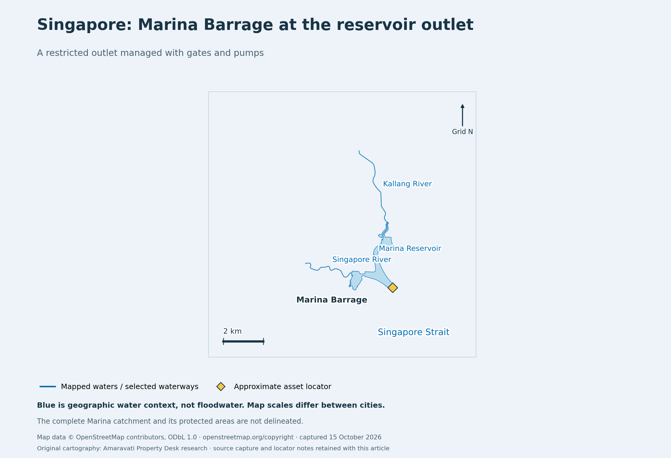
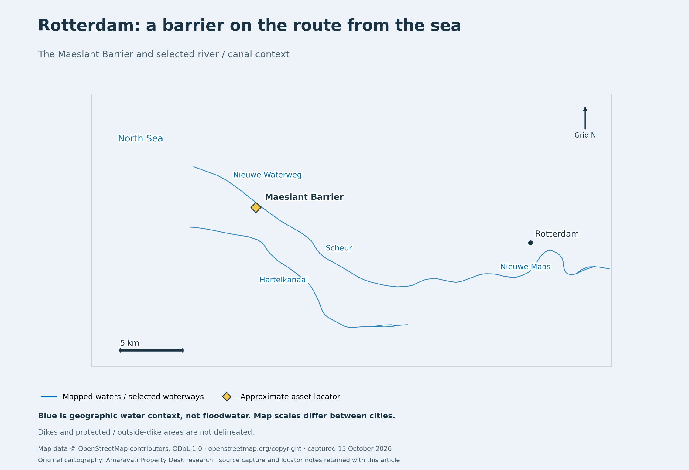
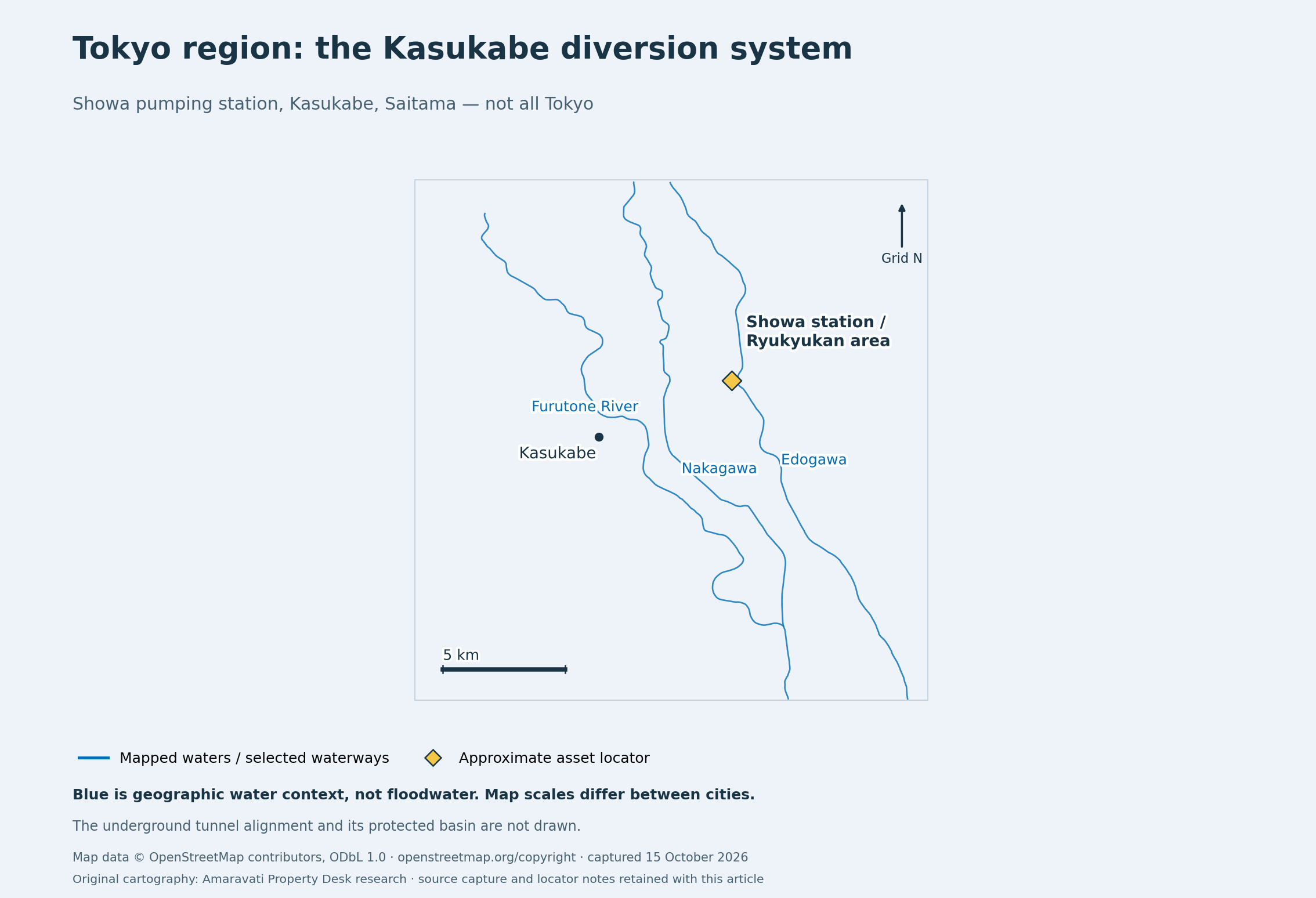
These comparisons concern mechanisms and public accountability. The maps have different scales and show selected geographic context; they do not show equivalent hazards, complete catchments or protected areas.
Singapore: a restricted outlet can be managed
PUB describes a direct operational response to a restricted outlet: nine crest gates release excess stormwater when the tide is low; pumps discharge it when the tide is high. The analogy to Amaravati is the need to move internal runoff when the receiving water is high. The receiving conditions themselves differ: Singapore is tidal; Amaravati’s constraint concerns the Krishna and its drainage system. PUB, Marina Barrage [15].
Singapore also retains public flood-prone-area and hotspot information. Pumps are one part of a system that includes drainage improvements, detention, property measures and maintenance. Their existence is evidence that engineering can manage difficult conditions; their performance and supporting institutions are what make the example useful. PUB, flood information [16]; stormwater management [17].
Rotterdam: protection belongs to a defined area
Rotterdam’s municipality distinguishes land behind dikes from areas outside them. It even explains that some outside-dike areas are higher than protected polders, yet remain exposed to high water. That is why an average elevation or a city’s name cannot tell a resident their protection status. Municipality of Rotterdam, outside-dike areas [18].
Rijkswaterstaat describes testing, inspection, repair and replacement at the Maeslant Barrier. For Amaravati, the lesson is to publish the protection boundary and demonstrate reliable operation. It does not follow that a government complex, a village, an LPS development and a river-edge access road share the same protection. Rijkswaterstaat, Maeslant Barrier [19].
Tokyo region: show what the infrastructure did
Japan’s Metropolitan Outer Area Underground Discharge Channel diverts floodwater from smaller rivers to the Edogawa. It is at Kasukabe in Saitama, not a protection system for all of Tokyo. MLIT’s brochure records 12.18 million cubic metres regulated during the October 2019 event. A documented operational result is stronger evidence than an artist’s impression or an approved budget. MLIT brochure, PDF page 3 [20].
Tokyo separately plans evacuation from exposed eastern lowlands. Engineering and preparedness work together. Amaravati would benefit from the same distinction between reducing the hazard and preparing for the risk that remains. Tokyo Metropolitan Government, eastern-lowland evacuation planning [21].
| International case | The useful test for Amaravati | What cannot be transferred |
|---|---|---|
| Singapore | Do local drains, storage and the final outlet function together when receiving water is high? | Singapore’s protection or flood probabilities. |
| Rotterdam | Which land is protected, by which works, and how are those works tested and maintained? | A sea-surge barrier’s performance in a different river/rainfall setting. |
| Kasukabe / Tokyo region | What do measured event logs demonstrate, and what is the emergency plan? | Protection for an entire metropolis from one basin’s facility. |
| Greater New Orleans | Is the hazard and design threshold stated clearly, including exceedance? | Hurricane-surge and subsidence conditions as a prediction for Amaravati. |
The last example helps decode a phrase often used in flood debates. USACE describes a 100-year level of storm-surge risk reduction around Greater New Orleans as a design event with a 1% annual chance. A “100-year” event is not scheduled to occur only once a century. With independent years and an unchanged 1% annual probability, the chance of at least one exceedance in 30 years is about 26%. This generic calculation is not Amaravati’s measured probability of flooding or household loss. USACE, HSDRRS [22]; public methods and evidence notes [1].
So, is Amaravati a suitable location to develop?
On the flood evidence reviewed, blanket rejection of the entire site is not established. There is a credible engineering case for development with mitigation. That is an editorial inference from the documented mechanisms, plans and experience elsewhere, not a certification that the final system is adequate.
The condition is that protection keeps pace with construction. Open farmland can temporarily absorb or store water; a built city produces different runoff. The city must preserve planned storage and flow paths, connect new neighbourhoods and existing villages to working outlets, and verify pumps, backup arrangements and maintenance before relying on them.
Five public records would make the safety case stronger:
- Scenario maps: flood depth and duration for stated rainfall and Krishna levels, including climate assumptions and pump or power failure.
- Operating evidence: commissioning certificates, test results, event logs, backup arrangements and a named maintenance authority.
- Complete drainage connections: the route from each developing area and village to the final outlet, including safe overflow and access routes.
- Construction sequencing: evidence that building activity does not consume storage or depend on protection that remains unfinished.
- Public risk information: dated hazard maps, water and pump status, warning procedures and emergency plans.
For a particular home, plot or site visit, the answer must be local: surveyed levels, the applicable flood scenario, drainage connectivity, access and the protection operating on that date. A whole-city article cannot issue that clearance. Overall capital-site selection also requires costs, environmental effects, livelihoods and alternative-site analysis beyond this flood assessment.
Amaravati’s strongest case is therefore a verifiable one: show where the water can go, which works are ready, how they performed, and what happens when their limits are exceeded.
Evidence and map notes
This article combines official documents, a dated satellite product, a reproducible surface-height calculation and original context maps. Official or operator reports are labelled as such; our interpretation is kept separate from independent verification. No hydraulic flood simulation, matched intercity risk ranking or individual-property inspection was performed.
The earlier claim search sampled six political/media items. It did not establish the exact universal wording “Amaravati floods every monsoon” in those items or prove deliberate fabrication by an identified outlet. Specific reports must be checked against their dates, locations and actual wording. public methods and evidence notes [1].
Map water geometry and approximate international asset locators use © OpenStreetMap contributors, available under the Open Database Licence [23]. The maps deliberately omit flood extents, protection boundaries and tunnel alignments that this research did not verify. No international elevation or pump-capacity ranking is implied. public methods and evidence notes [1].
NRSC’s original product is linked for inspection; its pages carry “For Official Use” and are not reproduced here as publication-cleared artwork. The Copernicus figure is our original analysis. Supporting government PDFs are source material, not a blanket licence to reuse their artwork.
Amaravati Property Desk is a property brokerage project. Sources, calculations and uncertainty are disclosed; this article is not an independent engineering certification.
Sources, dates and limits
- public methods and evidence notes
Amaravati Property Desk · Property Desk research · existing
Source date: · checked - MHA situation report, PDF page 8
Ministry of Home Affairs, Government of India · Official record · existing
Source date: · checked - World Bank technical assessment, paragraph 132, PDF page 57
World Bank · Official record · existing
Source date: · checked - Original NRSC product, PDF pages 3–4
NRSC / ISRO · Official record · existing
Source date: · checked - USACE HEC-RAS cross-section convention
US Army Corps of Engineers · Official record · existing
Source date: not stated · checked - NRSC Budameru model, PDF pages 4–8
NRSC / ISRO (hosted by APSAC) · Official record · existing
Source date: not stated · checked - Krishna district irrigation account
Water Resources Department / Krishna District, Government of Andhra Pradesh · Official record · existing
Source date: not stated · checked - 2018 EIA, sections 1.5.1 and 3.1.1, PDF pages 20 and 38
ADCL / APCRDA (hosted in the World Bank repository) · Project-party statement · existing
Source date: not stated · checked - Calculation receipt
Amaravati Property Desk · Property Desk research · existing
Source date: · checked - Copernicus product description
Copernicus Data Space Ecosystem / ESA · Official record · existing
Source date: not stated · checked - APCRDA-commissioned study, PDF pages 25 and 42–45
APCRDA / Government of Andhra Pradesh · Project-party statement · planned
Source date: not stated · checked - APCRDA compliance report, PDF page 6
APCRDA / Government of Andhra Pradesh · Project-party statement · planned
Source date: not stated · checked - January order
APCRDA / Government of Andhra Pradesh · Official record · sanctioned
Source date: · checked - February order
APCRDA / Government of Andhra Pradesh · Official record · sanctioned
Source date: · checked - PUB, Marina Barrage
PUB, Singapore’s National Water Agency · Official record · existing
Source date: not stated · checked - PUB, flood information
PUB, Singapore’s National Water Agency · Official record · existing
Source date: not stated · checked - stormwater management
PUB, Singapore’s National Water Agency · Official record · existing
Source date: not stated · checked - Municipality of Rotterdam, outside-dike areas
Municipality of Rotterdam · Official record · existing
Source date: not stated · checked - Rijkswaterstaat, Maeslant Barrier
Rijkswaterstaat · Official record · existing
Source date: not stated · checked - MLIT brochure, PDF page 3
Ministry of Land, Infrastructure, Transport and Tourism, Japan · Official record · existing
Source date: not stated · checked - Tokyo Metropolitan Government, eastern-lowland evacuation planning
Tokyo Metropolitan Government · Official record · existing
Source date: not stated · checked - USACE, HSDRRS
US Army Corps of Engineers · Official record · existing
Source date: not stated · checked - Open Database Licence
OpenStreetMap contributors / OpenStreetMap Foundation · Official record · existing
Source date: not stated · checked
Corrections
- — Corrected the source-list attribution of the 2018 EIA to ADCL/APCRDA (hosted by the World Bank) and restored a map-evidence note omitted during formatting. The flood findings are unchanged.